Category Archives: Field Notes

1974 Narrative

A Canal Ran Through It

There was little on the surface of this low spur of land overlooking the Basento valley and the coastal plain to indicate the extensive multiphase site that lay below. A few fragments of roof tile and pottery had been exposed by the plow and by a trial trench of the Soprintendenza made in the fall of 1973.

Capture

The site known as Pantanello (“little swamp”) gave up its secrets slowly, and in the case of both the Upper and the Lower Sanctuary, grudgingly. This first excavation campaign by the Institute of Classical Archaeology concentrated on the Tile Factory. By the middle of July, its east-west extent had been determined, but the discovery of the kilns was yet to come (see the 1975 campaign).

The Sanctuary site beside the modern canal was first identified as such in the course of the 1974 campaign. The concrete lining of an earlier era had been removed from the canal—which had been cleaned and widened—along with some eucalyptus trees, exposing a fresh face of bare earth on either side of the canal. The fresh cut had widened the canal and created a bank that was more than a meter high. Below the rich black soil of the overburden, at a depth of 60 cm beneath the canal’s upper edge, our cleaning revealed a continuous layer of roof tiles embedded in the banks on both sides, for a considerable distance. Capture2On the south bank, fragments of coarse pottery—including distinctive carinated lekane rims—were protruding. Further along the bank to the east, at the point where the Spring joined the canal, the pottery and roof tiles diminished. The archaeological level was more or less continuous, and visible for approximately 35 m. It extended from below the westernmost extent of the large structure on the hill, the “tile factory,” eastward to a point corresponding to the eastern edge, as it turned out, of the Sanctuary.


1974 Field Notebook 1, part ii

This page contains the transcribed notes from 1974 Pizzica Field Notebook 1.

(Field notebook 1, part i)

Pizzica 1974, Notebook 1: Field Notes

9 July 1974

Many surface finds. The group from Lecce V arrives. We continue to follow the transverse wall Beta–W into square XXXIX. Our 1.70 m wide trench uncovers a strip of Room 2 about 1.25 m wide. Our trench and the trial trench of October ’73 parallel each other. The excavators succeed in following the wall perfectly, missing it by several centimeters. The two trenches together cover an area 2.70 wide and the October trench lies bare to the hypothetical.

Surface Finds

Find: sherd with head of youth (?) by Parus painter (Adamesteanu), found by NF
Find: sherd of Iron Age (?) handle with gouged decoration, found by Mario
Find: sherd with part of amphora in R–F technique. 5th c. BC (Adamesteanu)

Level of the fall (had it extended to the north) of Room Gamma. In fact, the tile fall appears not to have extended further than 4 m north of Wall Alpha–N. To the east of Beta–W in Room 2 as noted, the tile fall is scarcer. It extends only to about 3.30 m north of Alpha–N. While cleaning the tile fall, under the tile a complete (nearly) ungentarium.

Find: Unguentarium, complete except for some breakage around the rim. Neck painted red, red streak on body; 1.30 m north of Alpha–N and 90 east of Beta–W. The tile fall is level with Beta–W. The full extent of Beta–W, measured from the southwest corner to the northwest corner, is 7.45 m. After N it turns back east, but there is no indication of any wall going west. The corner is very clean and the east–west wall Beta–N seems in good shape. An extensive file fall to the west of Beta–W, there is approximately no wall on the north to support the roof.

We decide rather than looking for the north wall from above to search for the west fall from below by putting a trench west along the line of Alpha–N. This trench will attempt to discover the westward extend of the tile fall evident in the wall of our early deep trench in XXVI–W. See notes from 1–2 July.

As we go the tile fall is cleaned. We discover a north-south wall, Gamma, just where Giuseppe indicates it will be. It is a looser construction than Alpha–N (larger stones, tightly-packed with two sharp faces, mostly carparo and occasionally the harder field stone). Alpha–W (squared blocks of carparo 40 cm across top) or Beta–W (similar to Alpha–W but with less carparo in proportion to the rounded field stones) but the wall has the same width: ca. 45 cm.


10 July 1974

Work begins about 7:10. Make more friendly noises with Cremonisi. Show him our huts and the spring; he shows us a pit with classical material, invites us to come over. We invite him over.

We extend the trench to the west balk of XXVII and start north along the line of the wall, leaving a meter on either side. Still in XXVII. The tile fall appears to continue to the west of the Wall γ.

I open a trial pit in the southwest corner of Room 2 where we have found vases. To the east were the discoveries of 2 July, to the north of the unguentarium of 9 July. The pit will measure 1.30 m by 1.30 m and will now extend farther to the east than the wall of the trench along Wall Gamma.

Make two battute. Below the tile layer 2 is composed of dark earth with many small stones, no material.  Wall γ continues up the hill. We have already passed the corner of Beta–W/Beta–N going north. The top of the wall is covered with carefully placed small sections of T–C tile. It measures 48 cm wide in three places measured; this corresponds exactly to the width of the carparo blocks with plow marks. The tiles, it becomes clear, were used to level the wall for the next course, as stones belonging to the wall are found over them and in situ (photographs). The corner where the wall turns east is discovered 11 July at 7:04 AM.

Work begins with Giuseppe and Alfredo 2 (general strike promised for today has gotten Alfredo 1). Continue northward. It is apparent that the wall continues northward. No material. What appears to be a transverse wall at 8 m from the east-west trench where γ was discovered, turns out only to be part of the fall. The wall continues and we follow it another before abandoning the chase at lunchtime. Mario, the specialist for the Lecce group, comes over. He, Giuseppe, and I discuss the walls and their different construction, and decide that Alpha, Beta, and Gamma represent various periods or phases of construction, based on the use or non-use of tiles.

  • Alpha — has no tiles
  • Beta — uses tiles to fill gaps between rocks
  • Gamma — uses tiles for leveling; the tiles lie directly on the ground—Mario says this kind of construction was employed in Late Roman (2nd or 3rd c.) villa in Mass Teresa; the tiles appear to be like those in the tile fall to the east

Group from Lecce (Cremonisi left yesterday) continues to find pits full of Classical material. Group from Lecce excavates our Hut B, finds tiles, map part of area a but. but like the other pits

Sounding in depth in square 12 W (2.0 x 4.0 m) below Wall Alpha–N.


Begin about 1:15 PM to clear soil off (topsoil) the tile fall. This part of the tile fall is in the ravine off the wall which has carried material from above XII–W 1.

This is the downhill side of the tile fall and as we dig further down the hill the layer of tile is deeper and deeper. The soil is also harder, slight;y darker and more clay-like, possibly as a result of the water shed in the rainy season. Tile fall encountered at a depth of 26 cm to 35 cm from ground level.

PZ74_FieldNotebook2_p13

Asia and I go down to the canal wall. We observe a great deal of pottery for the bank about 15 m down the canal from the point where two great stones laid side by side emerge from the bank of the canal. I clean these stones and on the opposite bank I find two other sets of stones, oriented obliquely to the banks, angled about 45° in a south–east direction.

Asia excavates a deposit of vases, broken and embedded in the stream bank about 15 m downstream. These are in the grey mud which forms the lower part of the bank (low water in the afternoon, because most is being used for irrigation). Mostly un-glazed ware. Very thus BG inside large coarse red vase. This in turn it would appear covered with a large yellow vase. Bottoms of two B–G cups.

This is not a random collection of sherds, but it would appear that canal was cut through a deposit (pit) or through part of a house.


12 July 1974

Begin to excavate on the north bank over the large blocks, cleared yesterday. They are about 1 m below the soil. We lay out a trench 2.0 x 4.9 m, northwest–southeast axis of trench mashes and the angle of 20° with magnetic east–west.

We lay the trench out so that it is parallel to the canal, and leave a balk of 50 cm between the canal and trench wall. Above the trench to the north is the bank of earth about 1.5 high thrown up by the canal cleaning machine. The treads of this have passed over our trench, making the ground very hard. Above, the north-west corner of the trench is a large squared block measuring, which may have come from the structure in the canal. The northwest corner stake of the trench is 61.35 m from the concrete bridge over the canal (to the west).

The blocks on the south bank are 4.40 from the south–west stake of the trench. The blocks appear to emerge from the bank in a north–east direction, 25° to the east of north. They appear to be aimed right at our southeast stake.

If, however, they are aligned with the large blocks which seem to be the eastern wall of the structure then they belong to a wall which makes an angle of approximately 50° with north. These large blocks are just inside our south–east stake.

The west wall ought to correspond to the block which emerges from the north bank m west of the “eastern wall”.

PZ74_FieldNotebook2_p18


15 July 1974

  1. Remeasure from the concrete bridge to the northwest stake of square: 61.10 m
  2. Concrete bridge to beginning of the tile fall on west: 82.50

Three workers continue the trench on the north bank of the canal. At 60 cm below the grass, they reach a layer of grey clay. Tiles, lots of bones appear. Adamesteanu visits:

  • 1° Greche longe morning(?) will study the T–C figurines
  • PZ74_FieldNotebook2_p20a
  • PZ74_FieldNotebook2_p20b
  • PZ74_FieldNotebook2_p21
  • At San Biagio a number of stipe. They are outside the sanctuary four or five meters. They are about four meters across, sometimes longer than wide.

In the grey few blocks appear at the level of the blocks in the canal wall. On the east end of the trench we go below the level and only tile and bone appear. We are at a depth of below the southeast stake.

At the west end, several large blocks of pudding stone run north–south through the trench. A number of tiles at the same level. We are below the southwest stake.

In the afternoon, three workers continue to deepen the trench. We encounter large rectangular blocks      m of carparo. It is only       cm thick. Other stones perhaps belonging to a wall. They are located for the most part in the western part of the trench. Is this fall from a wall located to the west? We decide to investigate the large block across the stream which Alfredo began on Tuesday.

Asia, Catherine, and Nelson work on plans of trenches. It is very hot and everyone is ready to quit at 4:00 PM.


16 July 1974

We continue to work on the blocks across the canal on the south side. It turns out not to belong to a wall. We open a trench above the tile fall beginning at 82.5 from the bridge. The trench is        m long and wide and flanks the trench without balk.

Finds 20, 21, 22: Nelson and Catherine are in charge of cleaning out the pit on the Lecce side of the caterpillar cut where the millstone and basin were found. In the afternoon I begin to scrape the bank where Saturday I found the small vases, and I find two more patera and a small amphora.

We uncover the tile fall. It rests on a mass of stone (Archaic wall construction has this kind of stone: see Amendolara). It is apparent that we will have to excavate a great deal more in order to be sure that it is in fact a wall, and in which direction it runs. It appears to be oblique and run in a southeast–northwest direction. This we decide to do not now, but next year. The workmen are tired of digging here. It is  hot and the soil is hard and does “yield” much.


17 July 1974

Giuseppe and I searched out a likely spot for a tomb on the north flank of the hill. We begin to dig a north–south strip about 1.0 m wide and 5.0 m long. After about an hour we hit it.

Tomb A

Flat slabs on either end, three rows of curved tiles. All tiles are broken from the pressure of the earth. The curved tiles are unusually large and reach way into the ground. The tomb is 180.0 long, 0.80 wide and 50.0 high. Tile which covers the east end is intact except for small crack. That at the west broken in several places. It is clear that the curved tiles were one piece and have a diameter of 80 cm.

The top is removed. The entire tomb is filled with fine soil. The feet are uncovered first. The body is oriented with the head to the west, facing the rising sun. Behind the head is a small lekythos (Find 23) with a missing handle. Sifting does not reveal it. Placed in the tomb, broken, a small cup (FIND 24) with one handle found. Removed skeleton and found amber signet ring (Find 25) on the left hand. Boy 1.42 m high.

About 30 cm to the north of the tomb, about 30 cm below the topsoil, at a slightly oblique angle (?) the post hole of a hut, Hut D. We save the wood of the post. NB: at the same level, a flint blade (Find 26), neolithic. The post hole is surrounded by a dense mass of irregular stones which form a layer that slopes upward to the east.


18 July 1974

Continue in the area of Hut D. Another post hole to the north and extensive bit of wood. It is suggested that the stones resemble the Iron Age burials of Mass Incoronata.

Alfredo Grieco II, via Setteubrini 2, Bernaldia

Alfredo Gattielli A, via Pagana 5, Bernaldi

Giuseppe di Taranto, via Michelangelo 15, Montescalgioso

1974 Field Notebook 1, part i

This page contains the transcribed notes from 1974 Pizzica Field Notebook 1

Pizzica 1974, Notebook 1

27 June 1974
The First Day

At 7:00 AM the weather is fully overcast, almost no breeze.

Continued clearing of surface fields on Square I. Have decided to dig in the southern half (i.e. 2 by 4 m) of the easternmost 4 m square: designated I–S. Joseph Carter is digging a test pit in the southwest corner, 1 m by 1 m.

Soil fields with small rocks that are rich dark brown in color; many small-featured rounded stones, pieces of tile, a small flint piece. N.B. rim of flat plate: black glaze piece. Ceramic finds as well as tiles. At ca. 6–7 cm larger rocks are encountered. Traces of charcoal, perhaps another level. Piece of red figure, 4th c. BC. Many small fragments of pottery.

Three workers arrive at 7:25 AM.

Level 1

Beginning at west end of rectangle, a few large stones, small piece of iron: flat, thin, undecorated. Several chunks of Roman ware as well as predominantly Greek. Terra sigillata? Greek pieces of differing black highest-quality glaze, shinier than others (5th c. BC, imported?)

At 30 cm in test pit, encountering a layer of hard pebbles. Color of the earth is redder, less brown and sandy, more clay-like.

  • Giuseppe di Taranto
  • Alfredo #1
  • Alfredo #2

Find #3: fragment of red figure with white over-painting; mid-section, left forearm of female figure; 6.8 cm wide/3.6 cm high; c. 10 cm down and c. 50 cm from south and east edges of Layer 1. Possibly Athena.

Layer 1 is plowed land. At 20 cm depth, the earth is composed of more clay then changes to chunks of yellow/gold earth. Still finding pieces of 4th c. BC Apulian figure and tile, some with white over-painting, and some large ribbed fragments singular to surface tiles. The yellow clay found in the earth is becoming darker, richer looking and filled with many small rocks.

At 26 cm, we are encountering what appears to be a patch of yellowish and whitish mixture of cement and small rocks in the southwest corner. One of the workmen—di Taranto—suggests this is virgin earth. A large rock at the eastern wall of the trench, its top at 13 cm depth, c. 2.4 m west of stake AI (AI 2.4 x –  A61.1 x –  13). Layer of yellow earth and pebbles extends over the trench; in going through this layer, we encounter Layer 2.

Level 2

IV–N 1

Although there are still many fragments of tile in this area, there appears to be fewer fragments, shards, than in I–S 1.

Lunch break.

13:00 –  the weather is hazy overcast; a fresh sea breeze

Just before beginning afternoon digging, one of the workmen found a votive face with black paint.

Find #4: 2 m north of eastern rim of III–N on the surface. Part of a face (eyes and nose) of votive plaque female figure.

The soil at the top level of IV–N 1 is almost identical to that of I–S 1. Perhaps IV–N is slightly looser. Finds: black glaze, some red figure.

I–S

Between Levels 1 and 2 directly west of the stone described above is a layer of natural conglomerate stone composed of large rounded pebbles. Workmen are digging in only the eastern half of the trench to determine if we have reached virgin soil.

Level 2 at this most superficial digging is more rocky and more densely compact than Level 1. It is, when broken up, lighter in color than the bottom of Level 1.

After reaching a depth of 34 cm in the southeast corner of the trench, JCC has decided to abandon digging in this area, since we have definitely encountered un-worked earth containing no material. A decision has been made to start at square IV north (IV–N).

Several fragments of Roman pottery from Level 1, as well as occasional pieces of bone, many tiles, pottery –  many black glaze.

Find #5: sherd; draped female figure, red-figure, 5.8 cm high x 5.8 cm wide, with arm extended; traces of white detail.

Soil is generally looser, less compact, perhaps indicating there will be more below. Workers have halved off the western end of the trench to determine whether or not bedrock soil is immediately (or approximately) below. Sherds are becoming scarcer, soil composition is thus far unchanged. In cutting back into the eastern half of the trench, sand is discovered.

Find #6: base of small terra-sigillata cup

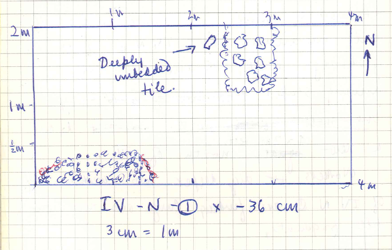
At the confine of Level 1 plowed earth, and Level 2 in the northeast corner of IV is a large piece of conglomerate stone. To the south is virgin earth (yellow sand and fine rock). To the north the soil is dark and fine. Tiles are deeply embedded. This is perhaps a cut. It begins about 30 cm from the trench wall. The conglomerate is 35 cm down from the edge of the trench wall. The coordinates are A-4 4.30 x A-5 4.90 x – 35.


28 June 1974
The Second Day

7:05 AM –  the weather is partly cloudy, with the sun already very bright and very warm; the air is cool, no breeze

7:15 AM – di Taranto arrives, both Alfredos

As workers shovel out small amounts of dirt remaining in IV–N 1 from yesterday’s work, IC and NF are driving stakes to cut a new 4.0 by 2.0 m rectangle north of IV. Workers digging deeper into the western half of IV–N 1 are finding large and numerous tile fragments.

The southwestern corner of this trench (IV–N 1) 2.70 m from A-5 and 4.70 m from A-4 there is a cut of a foundation through the southwestern edge of the trench, projection c. 30 cm at level – 36 cm.

PZ74_FieldNotebookI_p11

Photographs taken.

PZ74_FieldNotebookI_p12

PZ74_FieldNotebookI_p13

PZ74_FieldNotebookI_p14

PZ74_FieldNotebookI_p15

Workers are now digging XVIII–S 1 directly north (1.0 m balk) of IV (worker di Taranto is continuing to sweep and explore carefully in IV–N). Cutting into XVIII–S 1 immediately below the surface, soil is chunky, dry light brown—the same plowed earth as I–S and IV–N. Finding tiles, fragments of black glaze and Apulian red figure(?) in equal proportion.

Note: 2 small fragments in the southwest section of XVIII–S 1; one piece of red figure pottery showing a draped figure (?), measuring 4.5 cm x 2.0 cm; the other fragment showing black and red polychromy. In the center of the pit, a small pocket of rusty red earth was found.

In the southeast corner, the earth comes up in big chunks of yellow clay—the sort that we have been associating with virgin earth. This appears to have been turned up with a plow. There is a layer of charred wood. In the chunk examined the charred material occurs between the yellow clay and the brown earth.

At ca. 25 cm, 40 cm from the mid-point of the northern edge of the trench, is a patch of rusty red earth c. 18 inches in extent and flanked by yellow, dusty soil (later discovered to be only north of red earth).

PZ74_FieldNotebookI_p19

At this level of the trench, we are still finding sparse scatterings of black glaze sherds. This red earth, plus an increase in the number of small stones and sandy earth probably indicates we are reaching the bottom of Level 1 and getting (CUT OFF?)


1 July 1974
Pizzica

Tomb 1

The entire tomb is surrounded by a thin line of ash. After the hard-packed dirt was cleared, the whole surface of the tomb was ash. Bone began to appear and a few broken bits of pottery (no indication that whole pots had been deposited in the grave—perhaps the sherds shifted down from Level 1). Fragments of skull found in east end and vertebrae found in the middle. In the middle also were several chunks of iron mixed with the bone.

Find: Just above the iron (to the east), a large bit of bronze. Clearly the body was laid out in the tomb in the east–west direction with few ornaments of metal. It was burned, probably in the coffin. This would explain the regular outline of burned wood and the position of the skeleton

Tomb 2

Beginning to dig from the level of the red lines. At first the soil is full of small rocks with no material. We first encounter bones (sample A). Then at the midpoint along the northeast wall of the tomb. Tiles are embedded in the northwest end of the tomb.

Southwest wall of the trench found by T–C tiles turned up on edge (?) they disintegrate because burned.

Northeast wall of the trench there is a long strip, c. 50 cm of burned wood. Perhaps the bottom plank of a coffin. This is at a depth that the whole tomb could have been covered with tiles, the coffin inside, and burned.

Sample A from the southeast end of the tomb are large, un-burned bones from a higher level than the rest. Sample B comes from the southwest corner of the tomb, amidst burned wood and T–C.


2 July 1974

A burned layer, uniform over the floor occurs at a greater depth than that of Tomb 1. Just above it in the center of the tomb is the bottom of an amphora with point turned up. Chips out of it were bagged yesterday (1 July) in the Tomb 2 bag.

Revision: “The tiles turned” up on end are probably just burned earth. The tile at the end of the trench area is not in the tomb, but not in virgin soil or tilled earth either —perhaps belongs to another tomb.

Under the amphora are found large quantities of burned bone. The layer of ash and bone cleared. No further ceramic material found. The amphora was clearly burned.
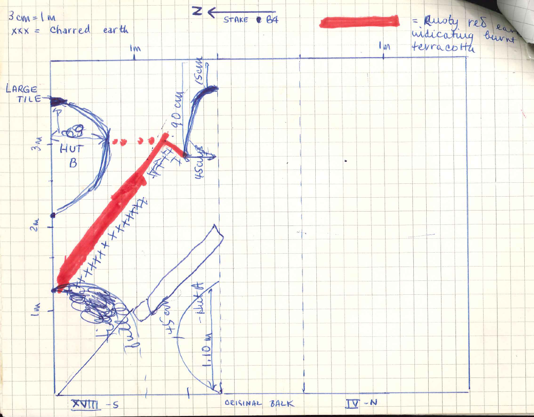
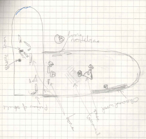
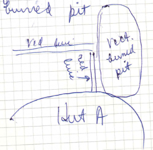
Hut A, XVIII–S 1

In the southwestern corner of XVIII–S  cut through 1 and down into 2.

Floor of the hut: traces of very fine ruddy soil and some yellowish traces. Pieces of bone, fluit impasto pottery found. Patches of sand.

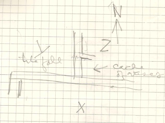
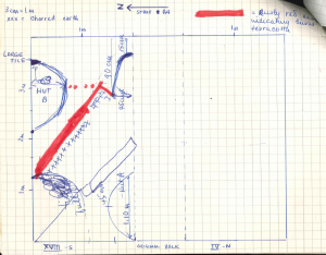
Just east of the hut, at the bottom of the plowed earth—i.e. Level 1—we have encountered a layer of burnt earth, with a mixture of more rusty red and yellow dusty soil. At just about the same level of the hut floor (c. 40 cm)—i.e. at 36 cm—is a layer of burned earth and burned rocks. This is about 25 cm outside the circumference of the hut.

Between the two sections of rusty red soil (shown on drawing of XVIII–S) is earth which has been disturbed. Following the first line of red in a northwesterly direction—about 1 m from the northwest corner—is a tile fall which is slightly above the red earth. Above the tiles was found a bone. This was possibly brought there by the plow. At the center of the trench at this level is some burned bone amidst the charred earth.

Note: foot of pot with black glaze, possibly archaic (?) was found in the burnt layer at the central pit. Also pieces of bone were found. This charred area is wider; it’s difficult to know if this pottery is from the level directly above.

Note: burned handle of a cup

Note: piece of archaic cup

12:20 PM – the weather is sunny, hot with little breeze

Pieces of bone from the charred area. At 35 cm, 20 cm from the southern edge of the trench, we found evidence of a plow (i.e. a scrape) c. 30 cm long and 3.0 cm wide.

At the walls of Hut A, Level 1 is peeled easily away, like onion skin, through virgin earth down to Level 2.

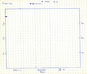
In the rectangular charred area (see plan), c. 35 cm from the south wall and 43 cm, there is evidence of a vertical stake which has been burnt off. It is located 2.20 m from stake B-4 and 3.10 m from B-5.

At Hut B, where a large tile fragment has been found in the earth, we are having difficulty in determining what is virgin earth and what is the cutting of the hut.

The two lines of red fine earth of supra parallel one another in a striking fashion (see drawing). On the more northern red line runs a line of charred material, approximately 50 cm in its extent from the northern edge of the trench.

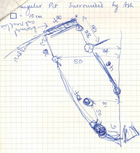
While clearing up the trench for photography, we have uncovered 4 more charcoalized stakes (see drawing). There is a great deal of charcoalized bone in the perimeter of this rectangle.

Notes:

  • With the discovery of Hut A, we began keeping a separate box for material. Therefrom, it consists of bone, impasto pottery. Encountering red lines, we began keeping a box of burned material 1/2 consisting of bone and some ceramic (sp?) archaic material.
  • Hut B finds were kept separately, and consist of many more impasto finds.
  • Burned red strips – terracotta.
  • Note, we will take samples to UT for carbon-14 testing.
  • Huts with impasto ware seem non-Greek.
  • Rectangular burned with stakes:
    • JCC thinks it is a shrine
    • workmen think it is a tomb
    • D’Andria thinks it is a hut
  • We’ll be looking for embedded wattle and daub walls

1 July 1974
The Third Day

7:00 AM – we and the workmen arrive simultaneously; the weather is clear sky, bright sun, cool air with a brisk breeze

Workers are removing the last half of balk between IV–N and XVIII–S in order that we might obtain better pictures of the cut observed in the southeast corner of XVIII–S and the northeast corner of IV–N. JCC is making a detailed drawing of the floor of XVIII–S. NF is assisting JC. BE is supervising the workmen, taking measurements of floor depths of XVIII–S (measurements on a vertical taken from the base of stake B-4).

Hut B

47 cm/48 cm

Hut A

47 cm/53 cm

Red line—northmost 46/48 cm
54—nearest trench wall/ 47—nearest hut/ 40—nearest southeast cut

Tile full 49/53 cm

Southern Red Line

@ (sp?) fall —57
near rectangular (sp?) 46

Stake 45, 47, 49

Rocks 40

Out of digging at balk

  • tile fragments
  • black glaze —some very thin

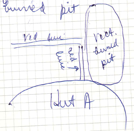
JC and BE have continued to work very carefully and cautiously in removing soil around the rectangular area with burned material, the two red lines and the possible hut/cut in the southeast corner. We have found a collection of tiles (fall?) under what was previously balk, i.e. 40 cm, 105 cm from the east wall of the trench—Hut C? Area with burned perimeter appears to be about the size of a grave.

We have also found a group of tiles at the southwest end of our burned rectangle. Southwest, rounded edge of the burned area is tangential to the tall of Hut A. The burned material, which is some

At the southwest end of the rectangular burned area rises c. 10 cm higher of Hut A, where 2 pieces of impasto are in situ. The mound at the end of the rectangular burned area consists of the same hard soil found inside the perimeter of the charcoal full of rocks, which constitutes hut floor. Soft brown soil lies under several 8.0 cm long and smaller charred stones. The corner of the rectangular pit surrounded by ash appears to cut into the wall of Hut A. Also in hard brown soil are a number of tiles.

The southerly red line flanks the edge of the rectangular burned pit.

PZ74_FieldNotebookI_p35

Embedded in the burned area is some pottery. Hard brown earth covers over virgin earth. Pieces of pottery were found in the brown earth under charred material.
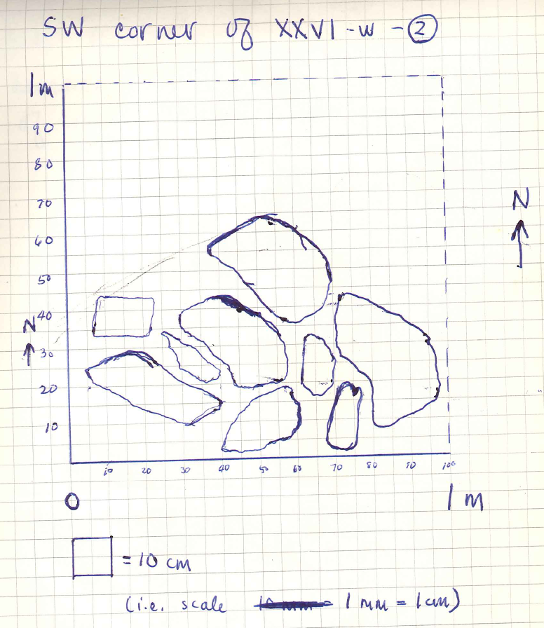
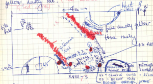
XXVI–W

While JC is completing detailed drawings of XVIII–S, workers have begun digging XXVI–W, which lies c. 1.5 m due west of the tile fall which was discovered by F. D’Andria for the Soprintendenza, October 1973 (excavated by di Taranto) and which helped lead to the decision to excavate at Pizzica. NF spent last Friday, 28 June 1974 and the earlier part of this morning in clearing up this trench and preparing it for photographing.

This surface soil resembles that which we have found farther up the hill, i.e. due east, although the former seems slightly more moist, i.e. not so dusty and coming up in bigger hunks.

There is a large amount of tile fragments just beneath the surface. Only a few pieces of bone have been found in Layer 1, piece of iron.

At c. 13 cm in the southwest corner of this trench, we have found the top of what appears to be an ancient wall. Beginning 1.10 m down the west wall from the northwest corner, a tile fall was discovered at 26 cm; 1.35 m wide along the west wall.

At this point, this tile fall is—by eye measurement—visually higher than the tile fall in the adjacent XXVI–E.

1:15 PM – for the afternoon digging, we have decided to halve XXVI–W along the north–south axis. We will be watching especially for finds behind our wall, and will dig down through our tile fall. We will keep all those fragments which we remove in order to approfundere.

At the level of the tile fall, the earth is packed and very hard; the workers are digging at a noticeably slower pace. Just north of the level of the tile fall, the earth is becoming much darker in color—almost black—and softer. There are still fragments of tile coming up.

Below the level of the wall, the soil is a tan clay which comes up in big hunks. It contains large quantities of tile next to the wall, and below the main visible layer of the tile fall.

Find: piece of archaic post with red and black concentric rings around the rim, measuring 4.0 cm x 2.0 cm x 1.7 cm. It was found under the tile fall, c. 10 cm.

Work concluded, a decision was made to continue digging deeper using the 2 Alfredos until di Taranto has completed his work in XVIII–S of infra for description of today’s excavations in XVIII–S.

PZ74_FieldNotebookI_p41

Two Alfredos will follow the path of the wall to attempt to discover the nature of the structure of which this forms a part.


2 July 1974
The Fourth Day

7:00 AM – all arrive a’ l’heure; weather is clear, cool with no breeze and warm sun with the promise of a hot day

We are continuing our digging down in XXVI–W 2, below the fall which we found yesterday, and in front of (or behind) the wall in the southern end of the trench. We are finding almost no tile fragments now, and only occasional fragments of pottery.

We have found several small pieces of bone in the wall of the trench directly beneath the wall in the southwest corner. This comes from Layer 3, which appears as a moister layer 13 cm below the beginning of Layer 2.


After following layer 3.0 to 14 cm, we have ceased digging in trench XXVI–W and have turned in a southwesterly direction to pursue the course of the wall discovered in XXVI–W 2 at 13 cm in the southwest corner. We find immediately that the wall does not run southeast and are digging northwesterly and northeasterly. We are keeping a separate box for fragments found between the ground surface and the top of the wall: a few sherds are coming up from the top, along with many fragments of tile.

The line of the tile fall in XXVI–W 2 runs slightly above (almost equal to) the top of the wall.

1:10 PM – we spent from 9:30 to 12:00 following the top of the wall. We have decided to remove the plowed earth (Layer 1) from along the entire top of the wall, and after that to dig a series of deep trenches which run perpendicular into the wall. Work goes well, but slowly, since the earth here is very hard and the heat high with little relieving breeze.

We are now following a section of the wall which runs NNE and will, at least for some portion, parallel di Andria’s trench of discovered tile fall.

The earth here, as with every place that we have dug thus far, is ploughed land which has been worked in recent times. On a large wall stone 80 cm north (and slightly west) of stake B13, we found a large plough scrape at 11 cm as measured from the base of B13 (the plow scrape measured  0.80 m from B-13). In the section of the wall (running SSW from XXVI–W into XIII–E) we have found a piece of glass (from a modern bottle?) at a depth of 28 cm!

At 1.0 m due east of B-12 at 40 cm, we have discovered a number of pots under the tile fall —this due north of the wall (photographs taken). We have also found some pieces of bone, some burned material.

Thinner wall, buff colored coarse ware under one large tile, pieces shattered, base up, pieces surrounded in a circle. Obviously the pot was whole when the roof fell—this would perhaps lead us to conclude the date of the falling in of the roof, and perhaps leads us to conclusions concerning this farmhouse’s falling into disuse. Difficulty in pursuing the path of the wall, shifting stretch. Black earth turned up just north of the double wall. Alfredo #1 dug SSW across portal.

Find: white glass, north of double wall measurements

Find: fragment of bone found with buff-colored pot


3 July 1974
The Fifth Day

Weather is cool; clear sky and warm sun with little breeze.

Our purpose today will be to attempt once again to follow the top surface of our (house? stable?) wall and to make some sense of the double wall (which we discovered yesterday on the south side of B-12).

Yesterday’s digging, roughly sketched:

PZ74_FieldNotebookI_p48

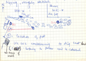
We are continuing to dig last lead (c. 110°), hoping to follow and re-establish no trace of wall. Pursuing our easterly course, the soil coming up—from over the double wall is moister, darker—almost black and softer. This indicating this particular earth has been used for vegetation.

Alfredo #2 is clearing at XVIII–S (the dirt from yesterday’s excavation of NF) and digging down in the northwest corner pit.

Find: lead, semi-circular piece, measuring 4.6 cm across, 3.0 cm wide, found c. 2.0 m east of B-12 (and in the balk between XI and XXV, Layer 1).

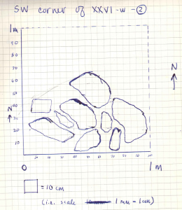
The double wall which we are following measures, at B-12, 1.0 m wide and is made up if 4 courses of stone (2 courses per level of the wall). The perplexing question at the moment is: why these two levels? Alfredo #1 suggests that the higher, i.e. northern course of the wall, may be a section which has fallen from its adjacent section. This would be impossible however, because the higher course is in a perfectly cut line—there is nothing fortuitous about its position. The higher course is 9 cm above the lower. The upper course runs 110°E—at B-12.

Find: remains of pot #2 found on north side of the wall, at wall level, Layer 2 (also a small piece of bone, 1.80 m from B-12). Purkish ware, large stone amphora found upside down with no tile found directly above it (photographs taken in situ). Would seem to strengthen our belief that the north side of the wall was the interior of a building.

From layer 1, a piece of “loomweight” with geometric patterns—from south side of the wall, 1.50 cm c. of pol

At 1.30 m, 104°ESE of B-12, the wall drops off ca. 10 cm and leaves a gap of c. 0.50 m before the lower (i.e. southern) course resumes. Ca. 1.0 m after this resumption, several rocks seem to lie—as if fallen—against the northern side of this lower course. At 45 cm further east, the upper (i.e. northern) course of the wall resumes also.

As we continue digging in ESE direction, our double wall continues. There are very few pottery sherds coming up, although there are still many fragments of tile. Perhaps when the house was abandoned, the inhabitants moved everything out except several pots which either were not needed during the move or perhaps were defective.

The higher, i.e. more northernly course, is one again broken down midway between B12 and B11, and re-begins after a 1.50 m interruption, suggesting that this wall was older and fell into disrepair, and was then replaced by the southly, lower course. This one is more solidly constructed and in a batter state of preservation.

Along the northerly side of the present trench, mid-way between B-12 and B-11, and running up to the trench wall in front of B-11 there is evidence of another tile fall.

  • southerly course — Alpha
  • northerly course — Beta

4 July 1974
The Sixth Day

7:00 AM – the weather is clear sky, cool air, warm sun, and little breeze

All three workers continuing the work on which we were engaged all day yesterday, following our wall in an ESE direction.

Measured north/south on a line between A-11 and B-11, the northern course of the wall is ca. 2.2 m from B-11. Since we are digging uphill, the digging takes longer to remove the top soil from the wall. The earth contains a gathering of tile fragments and practically no pottery sherds.

At 1.35 m due east of A-11 (for the southern wall of the trench) we have decided to reduce the width of the present trench by about half in order to hasten the digging over the lower, i.e. southern course of the wall.

The earth atop each course of the wall is identical. The only exception to this was over the break in the northern course (cf. notes 3 July 1974) where the earth was a rich dark/black color indicating vegetation above.

Find: bronze nail with round head, measuring 2.5 cm long; the head has a diameter 1.4 cm from X–S 1.

We have removed stake A-10 since the wall passes directly under.

At several places along the wall, a plow has perhaps scraped part of the wall so that rocks have fallen along the south side (these lower “fallen” rocks may also be the walls of rooms leading off the main wall). Finally just before lunch we think we have come to a turn (break?) in the wall. At approximately under where the stake A-10 was driven, we have found that the wall turns c. 90° SSW, i.e. to approximately 200°.

This new section of wall is found to be “too intermittent” in the first two meters to determine whether or not it constituted one of the principle walls of the building. It will probably be necessary to dig deeper in order to determine if this formed a main wall. The soil in which we have been digging since turning SSW is the same ploughed earth which we have encountered all along. However, there seems to be an almost complete absence of pottery sherds, as well as a real decrease even in the number of tile fragments.


5 July 1974
The Seventh Day

Weather – bright sun, slight breeze; the air is not so cool as usual for this time of day

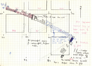
Vertical measurements from the surface of the trench to the top of Wall Alpha:

  • at the line between A-10 and B-10: 27.0 cm
  • at the line between A-11 and B-11: 27.5 cm
  • at the line between A-12 and B-12: 32.0 cm

Our main purpose today is to follow the wall surface in a SSW direction and  probably to attempt to anticipate some of the lower course by breaking off at some point in the present trench and moving down the hill.

In the first 2.0 m after turning SSW, the wall continues to show evidence of having been torn by the plow. We have suspended digging at a point along B’ east-west axis —at approximately B’-10— and have moved down the hill c. 3.0 m to dig a soundage (midway between B’-11 and C’-11) to determine the course of our wall.

Find: “loomweight” from soundage between B’-11 and C’-11, Layer 1; 6.0 cm long x 3.2 cm x 2.4 cm. We have decided in this soundage to dig to virgin earth.

At c. 40 cm on the northern side of our soundage, we have found the tile fall. This marks the end of Layer 1 and the beginning of Layer 2. If we are over the course of the wall, we should encounter it below this level (cf. northern wall of trench, which led from XXVI–W in a ESE direction to A-10 (i.e. our 16 m wall whose eastern corner we turned yesterday).

In our soundage, northern wall:

  • Level 1 —surface to ca. 38 cm
  • Level 2 —ca. 30 cm
  • Level 3 —

These show the same color and texture differentiation as the western trench wall of XXVI–W (cf. drawing of section of XXVI–W made 3 July 1974).

PZ74_FieldNotebookI_p60

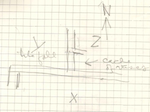
  • 50 cm—tile to eastern wall
  • from tile to edge of Hut B—1.40 m
  • from edge of Hut B to Red Line—0.90
  • from Red Line to edge of trench—1.10

Hut B at its widest is 62 cm, 50 cm from its eastern edge.

Red Line at its furthest extent is 1.15 m from the trench wall, and is opposite to Hut B at its widest point.

Red Line—6 cm.

Between the Red Line and the hut is virgin earth (yellow sand and pebbles).

Second Red Line—80 cm off from the first, i.e. northern red line.

Hut A—45 cm at apex.

Stake 1—56 cm from south wall, 120 cm from east wall


8 July 1974
The Eighth Day

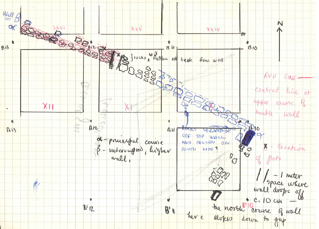
Work begins at 7:07 AM. We have decided to turn our attention to finding the north wall of the building, the roof of which is represented by the tile fall in section XXVI. We begin by removing the small projection where stake B-12 stood. Under this there is some indication of a transverse wall. We will widen the trench of October 1973 in area XXVI. The wall runs along the line between XXV and XXVI.

Nelson is employed in removing the dirt piled up beside the trench (G. suggests that the way to find the lower wall parallel to our x is to cut a transverse trench about 15 m to the south. This we will do later.

Layer 1 is above the tile fall and the wall—sherds of coarse ware.

Wall confirmed by further stones. It extends at least 4.0 m north where we have encountered large blocks.

The morning is spent in widening the trench to uncover the transverse wall, and in clearing off the tile fall for photographing. Many unusually large and nearly complete tiles. The wall turns out to be formed of large blocks like those in X–W. These also have plow marks in the east-west direction.

Just to the east of the tile wall and to the north of the doubled wall X–N Beta–S are more vases buried upright in the ground. These go with those discovered by BE on 2 July (?). The transverse wall Beta–W seems after about a meter to turn east, as if to form a small room (pantry?)

We decided to widen farther the trench over the transverse wall—1.0 m further to the east, still in square XXV. We are over Room Z. There appears also to be a tile fall over Room Z, but it is higher and thinner than that over Y.

PZ74_FieldNotebookI_p68

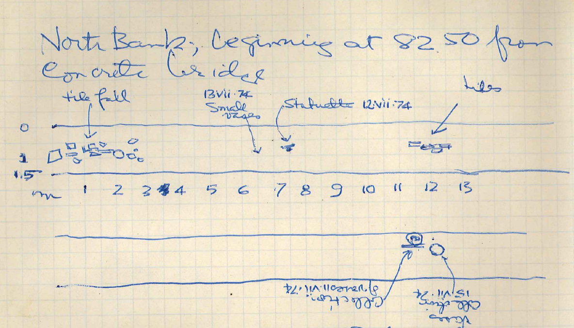
This afternoon went with Giuseppe along the canal at the foot of the hill, walking east from Conarete Bridge we see in the east wall of the canal large blocks projecting from either side. Two sets spaced about 5.0 m apart looks as if the canal cut through an ancient building. The archaeological stration is about 1.0 m below the rich black surface soil. All along tiles are embedded in the wall. Farther east on the south bank we see two groups of vases and bone (sp?) and make a collection—and box it. See Canal Wall 8.vii.74. It is coarse ware but unusual shapes. There is one large tile fall on the north bank.

I later proceeded as far as the point where our spring joins the canal. There archaeological material is scarce. It would appear that whatever habitation, sanctuary, etc? was here below out farmhouse.

It would be nice to explore but must talk first to Indice-Canal belongs to Consozio Bonifica, which also ought to have a detailed map of area. The canal here recently has been widened. The (sp?) cut  above and the concrete walls broken up. Many blocks of concrete around too.

Among the tiles in the extension to the east, appear vase fragments including complete rim and bone. These form as closest for dating the fall in as they were clearly broken by the fall and remained in place. Also several fragments of bone.

Find. _____

(continued in part ii)

1978 Field Notebook 1, part ii

Note: This page contains the transcribed notes from Notebooks 1–5 and X.

Notebooks 1–3 contain day to day field notes, while 4 and 5 are summaries of those notes. Notebook X is Prof. Carter’s personal notes from the season.

Pizzica 1978, Notebook #1: Field Notes, pp. 1–41

June 15, 1978 (continued from part i)

L’1, L’-1, Level 1, batt. 5.

Shallow battuta carried out cleaning around and up to tile concentration in L’-1. Bone frags, a circular loom weight and a few small sherds found.

Finds: PZ-78-20PL, PZ-78-21TPZ-78-22B

L’1, Level 1, batt. 6.

North of irrigation ditch. Another battuta has been begun and it will extend eastward toward the tile and stone concentration in L’-1. Nothing has changed in terms of soil. Numbers of tiles seems to be increasing; possible the fall in L’-1 slopes downward into L’1.

L’1, Level 2 (New).

South of irrigation ditch. Area of tile fall has been cleared to area of tile fall in M’1.

L’-1, Level 2.

South of irrigation canal. Cleaning of wall. A large pyramidal loom weight has been found in the course of the cleaning of the wall ( a special find in this case).

The tile and stone fall found last year in M’1, M’-1 apparently continues over the wall in L’-1 and into the section of L’-1 north of the canal.

Finds: PZ-78-28TPZ-78-27SS comp. sample of gravel pavement

L’1, Level 2 (New).

South of irrigation canal. The batt. has been completed and the tile fall doesn’t extend into the western corner of the area. As mentioned above this stone [sentence ends abruptly]

L’1, Level 1, batt 6.

Numerous sherds in the material which Prof. Carter has identified as imitation terra sigillata in keeping with present view that we have an intrusion of the Roman dump.

M’-1, Level 4, batt 1.

Area north of wall. Excavation of 1977 season took out both level 2 (area of pavement) and level 3 (area below pavement). Now level 4 designated as beginning from top of the next wall in the southern portion of the square. Material is completely of the sixth century: Ionic cups, rims, spout of type which seems to be smelting spout. Carter, “Nothing any later than the end of 6th century. What’s it doing here…Could be early fifth.” Soil gray clay w/conc. and streaks of red around.

M’1, Level 2.

Clearing of Tile fall. Tile fall area now being cleaned. Several large amphora frags.

M’-1, Level 4.

Area south of wall. Less material than in area north of wall. Most sherds are nondescript courseware, one frag with banded decoration which appears to be 6th, however there is also a frag of Gnathia-type ribbed ware (4th c.) and a Kean type amphora handle. Also some black glaze frags. Material south of wall certainly lacks the consistent 6th c. nature of the material north of the wall.

M’-1, M’1, Level 4, batt. 1.

South of wall and almost on M’1 axis a statuette has been found; head is missing otherwise body is complete; fig. of a goddess. Wall ends after about 2 m and batt. now extends along full axis of square unint. and is working into M’1. Very near M’-1 stake another statuette frag has been found; this belongs to a larger plaque, only area of breasts and stomach survive with striation on either side belonging to long hair or garment over arms.

This battuta is at same level as level 4, batt. 1, however in the cleaning of the Roman stones and tiles in M’1 it is entering the level 2 of that square which opens up grounds for confusion. A mixture of Roman and Greek material thus would be expected. Some coarseware frags appear to be Roman; there are some black glaze frags, and some frags which appear to be 6th c. in keeping with level 4, also a lump of slag was found which is interesting since a smelting spout was found c. 1.5 m due east in the same level.

June 16, 1978

Levels

Level 2. Area of tile fall terminology has been maintained in M’1 and Level 4 batt. 1 maintained in M’-1. The combined square batt and end of previous day contained material from both levels, the excavator to the best of his ability has separated the material. Some mistake in separating may have occurred but it will involve no more than a few pieces of nondescript coarseware. Level 2 and 4, batt. 1 ands at same stratigraphic level, their differentiation is as follows:

Level 2 = area of Roman deposit of tile and stone which overlaps the earlier Greek walls and extends through squares M’1, M’-1, L’1, L’-1.

Level 4, batt. 1 = level associated with wall in southern half of M’-1 (as yet unchristened), The level 2 above this is the area of the gravel pavement associated with the wall in the north section of M’-1, and level 3 is the area directly below this. Level 2 and above the wall associated with level 4, batt 1. Levels 2 and 3 were excavated in the 1977 season where they were called level 2, batt. 1 and 2. The gravel pavement was not recognized by the excavator. Material included several black glaze frags and a lekane rim.

M’1, Level 2, batt. 1.

Area of tile fall. Work continues on clearing out the Roman tile and stone deposit. Many frags of amphora and other large vessels. Photographs taken. Levels taken from K’1, K’-1 whose actual level is -7.16m as sighted from M’1, M’-1.

A = -8.61m, find spot of full body fig., level 4, batt. 1
B = -8.47m, end of wall
C = -8.46m, find spot of fig frag, level 4, batt. 1
D = -8.55m, NE corner of M’-1 beside baulk along wall
E = -8.65m, SE corner of M’-1 beside baulk along wall
F = -8.62m, SE corner of M’1, level 2, batt. 1
G = -8.53m, NE corner of M’1, level 2, batt. 1
H = -8.55m, NW corner of M’1, level 2, batt. 1

M’1, Level 2, batt. 2.

Another battuta begun to clear out the Roman tile and stone deposit. Large number of tiles and stones remain. Materials are once again frags of amphorae and other coarseware vessel with some circular loom weights. At bottom of battuta a high density of tiles and stone no longer appears, therefore it seems that we are finally through this deposit of Roman material. A bit of mixture has appeared with a few Greek sherds of 6th, 5th, 4th type found along with the Roman coarseware.

M’-1, Level 4, batt. 2.

Work begun on this battuta with separate boxes for the areas north and south of wall in south half of square. Soil north of wall is gray with high sand content. The soil south of wall has a very high clay content, gray in color with some streaks of red sand. South of wall several tiles, some bronze frags, a votive vessel, and other frags have been found and are being trowelled by Prof. Carter. Possible indication of a floor associated with the wall. North of the wall a small frag of what appears to be an enthroned fig has been found along with a large lekane rim fragment. South of the wall the streaks of red sand in the clay run throughout the matrix; in some places c. 0.10 m in width with some concentrations. South of the wall conc. of material – thin sheet of bronze with one curving edge, possibly originally part of a circular piece. Large concentrations of pottery fragments including a broken but whole votive vessel. Material both N and S of wall is to all appearances purely of the 6th c. even though it stratigraphically is too high. Prof. Carter believes that for this conc. to have maintained its purity it could not have moved too far. Poss. washed from the west nearby to present location. South of wall. Among finds is a strip of iron and the head of a nail. North of wall. In addition to large number of 6th c. sherds there were several stat. frags including a large and small head. Giuseppe says that there is a pavement at the bottom of the battuta. If it is the 6th c. pavement our problem of the presence of the 6th C material is solved. South of wall. in the conc of sherds there was a concentration of carbon buses; one of the frag vessels showed signs of being burned. All of stat found in M’-1, level 4, battutas 1-3 have been found in the northwestern corner of the square.

Finds: PZ-78-65PL, PZ-78-66P half of a cup, PZ-78-67B shell frags, PZ-78-68M metal frags

1978 Field Notebook 1, part i

Note: This page contains the transcribed notes from Notebooks 1–5 and X.

Notebooks 1–3 contain day to day field notes, while 4 and 5 are summaries of those notes. Notebook X is Prof. Carter’s personal notes from the season.

Pizzica 1978, Notebook #1: Field Notes, pp. 1–41

June 12, 1978

[ark_link lot=PZ_77.0725]

L’-1, L’1. Level 1, batt. 1.

Excavation begun in attempt to locate east extension of the farmhouse. *Soil is dark and blackish; finds are few in number: one fragment of black glaze ware, greyware bases and various nondescript handles and a  couple handles.* Level of battuta is 0.14–0.15 m down from the present top surface. A more proper level will be taken. The east side of L’-1 is slightly shallower than the rest of the level (0.12–0.13 m in depth).

* Also the extent of the tile fall and concentration of stones

M’1.

Soil of level corresponds to dark level of topsoil present in baulks throughout the site. It will be necessary to check the levels drawn last year to correlate the level terminology. The first signs of the old irrigation canal have now appeared in the southern half of M’1: yellowish soil. *Also found were a few small fragments of Arretine, T.S., or …. ware which would put level into 1st century BC at earliest.

Finds: PZ-78-4PLPZ-78-5P


[ark_link lot=PZ_78.0005]

[ark_tc lot=PZ_78.0005 sf=lot_spat_display]

[ark_tc lot=PZ_78.0005 sf=sfsheet_img_display]

[ark_tc lot=PZ_78.0005 sf=lot_asm_display]

[ark_tc lot=PZ_78.0006 sf=sfsheet_img_display]

L’1, L’-1, M’1, and M’-1.

Old channel, meter wide area excavated in 1976 down to level 2, cut from the 1976 season, and tile fall excavated in 1977.

L’1, L’-2. Level 1, batt. 2.

Second battuta begun and in a bit of a quandary. The soil appears to be browner than batt. 1 (“chocolate-y” in tiny). Material in quality is the same, the quantity may be slightly greater but very little. Difference in soil color may be solely due to the light which is highly variable, difference in moisture content, etc. Material doesn’t seem to warrant the designation of batt. as level 2. Necessary to check Ruth’s notes for her dealing with levels of M’1 (notes are still in Texas, this will have to wait). As best as I can figure, batt. 1 and 2 equal the level 1 of 1976 season, the top of which level was formed by a bulldozer cut out of the side of the hill. The drying of the soil during lunch has evened out the coloration of the soil, and reduced the doubts raised above. Pickings continue to be slim. Various nondescript sherds plus a few more sherds of Arretine-type ware in keeping with the first battuta.

Roman nature of first level corresponds with my memory of the materials found in the upper levels in M’1 in the 1977 season. Prof Carter has raised the question as to whether this is a continuation of the Roman dump in the N-S trench. Work slowed due to continued problems with the well point system.

Finds: PZ-78-7B large bone fragment

June 13, 1978

Work continues on batt. Munsell color reading of soil taken: 10YR 4/1 dark grey, moist. Soil texture is sandy. Color reading on old canal: 10YR ⅞ yellow, moist with many rocks and pebbles and streaks of dark clay. Previous days ramblings on color now seem a bit ridiculous. Work continues at a slow pace. Batt 2 measures at 0.30-0.31m below original surface with some variation as would be expected. Concentration of finds was higher in L’1 than in L’-1. The greater quantity of sherds in L’1 may be associated with activity in the area indicated by the tile and rock fall in M’1. The next level should bring to light a continuation of the fall in M’1.

Level 1, batt. 2 finally completed, sherds few in number: one Arrentine-type ware fragments, a black glaze frag., grey ware frag., lumps of metal or iron slag, and various nondescript sherds. No features visible other than the trace of the modern irrigation canal.

Finds: PZ-78-8PLPZ-78-9B bone joint

June 14, 1978

L’1, L’-1, Level 1, batt. 3.

Work finally begins on next batt. The area of the irrigation canal will be left unexcavated from this point. The naming of the level will have to wait until a good sample of the material and soil can be examined. Also will have to discuss the nomenclature of the level with Ingrid.

Levels → The confusion over the soil of level 1 was solved late yesterday when I finally took a good look at the walls of the squares. The dark blackish soil reported in the discussion of level 1, batt. 1 derives from a  thin layer of topsoil varying in depth from 0.12-0.13m which has collected since the cut was made by the bulldozer. A layer of gray soil below this constitutes the first true level of undisturbed soil. The first batt. consisted of a mixture of these two soils, and the majority of finds can be attributed to the grey soil, although discarded sherds, tiles, etc. no doubt were present in the top soil level. Whether the designations of level 1, batt. 1 and level 1, batt. 2 will remain unchanged will be determined after discussions with Profs. Carter and Edlund.

Finds: PZ-78-11B 2 bone frags and 1 tooth

L’1, L’-1, Level 1, batt. 3.

Battuta 3 finished on both sides on the irrigation canal, depth varies from 0.44–0.49 m from surface. Soil once again appears to be identical to soil in previous batt. Quantity of material small: a couple grey ware frags, a few small frags of Arretine-type ware, various assorted frags of courseware, the molars of a cow, and a tile frag with a joining notch.

Levels → Beginning with the next battuta the finds on either side of the irrigation canal will be kept separate from one another.

No level report drawn for level 1, batt. 3. No visible features except for irrigation canal and signs of some tiles and stones just at the surface.

Finds: PZ-78-12PL

L’1, L’-1, Level 1, batt. 4.

South of irrigation canal soil appears to be same grey sandy soil with which we have been dealing; consistency is more sticky, but this is probably due to presence of more moisture rather than a significant increase in the clay content. The number of tiles and stones present increased greatly, however the were not of such a concentration to indicate a tile fall. Sherds were very few in number, however they may finally indicate a departure from the Roman period. There were … frags of black glaze ware including two frags from the bases of cups. There is one small sherd which may be Arrentine-type ware, however I think that it si simply a sherd composed of fine reddish clay. Its surface in not polished enough for the Arretine-type ware. Cut was shallower than usual due to concentration of tiles and stones, 0.20–0.22 m in depth measured from surface af now unexcavated irrigation canal.

Levels → Battutas 1-3 will remain Level 1. Level 2 is now designated seems to correspond to the Level 2 of the 1977 season in this area.

Finds: PZ-78-13P Black glaze sherd

L’1, L’-1, Level 1, batt. 4.

North of irrigation canal. Soil remains unchanged. Increased concentration of tiles and stones is in area south of canal. Quantity of sherds continues to be small, and the non Roman nature of the level continues to hold. Some red ware has been found, but it does not appear to be of Arrentine-type. A large decorated black glaze frag has been found by Alfredo the Good. Several bone frags including a large frag of a cow bone also are present.

Finds: PZ-78-14PL

L’1, L’-1, Level 1, batt. 4.

North of irrigation ditch. Prof Carter believes that this material is a simply a continuation of the dump found in the nearby N-S trench. If so we will shortly be down to the level of virgin soil in the N-S trench.

Finds: PZ-78-15P black glaze sherd with rf. leaf design, PZ-78-16TPZ-78-17B bone

L’-1, Level 1, batt. 5.

At top of this level of technically even in Level 3 trowel was done around the wall in L’-1. Numerous bone frags were found associated with the wall, these frags have been covered with aluminum foil and bagged separately in a paper bag.

Finds: PZ-78-18PL, PZ-78-19B bone frags

L’1, L’-1, level 1, batt. 4.

North of irrigation ditch. Level completed, no features in L’1. In L’-1 there are several large concentrations of stone and tile. Some of rocks may be part of a crosswall of the wall in L’-1 south of the irrigation ditch. Numerous large tile frags of a flat type with upturned edges; clay of tiles is reddish-orange. Exact nature of tiles and stones is still not certain.

June 15, 1978

Down to top of wall in L’-1 we have same gray soil associated with upper area. Associated with wall is a layer of dry and gritty soil (won’t matter, virtually sterile; what material there is all mixed up in just above and below, some small frags of charcoal) with a layer of gravel south of the wall, material from this layer in char. Greek material, including a lekane rim. Level 2 = layer of the pavement associated with the wall. Level 1 = everything down to well and pavement. Level 3 = area below wall and pavement. Level 2 = Tile fall and below in L’1.

L’1, Level 2 (in fall)

South of irrigation canal. Going through a concentration of tiles which in probably a continuation of tile fall in M’1. Material is Greek. Pavement in L’-1 south of irrigation canal associated with wall doesn’t appear in the area.

Finds: PZ-78-24PLPZ-78-25S gray sandy stone, possibly a grinding dish, PZ-78-26B bone joint frags

L’1, Level 1, batt. 6.

North of irrigation canal. Taken down features in L’1 were not affected, left untouched.

M’-1, Level 4, batt. 1.

When excavation of M’-1 begins it will be lower portion of level 3. Level 2 the area of pavement probably extended throughout the square based on Prof. Carter’s observations. The 1977 excavation of the square went through this level and also took out the top portion of Level 3, the area below the pavement.

A sample of the gravel pavement have been taken for later comparison with other soil, sample not for analysis.

TAKING OF ACTUAL LEVELS: Levels will be taken from K’1, K’-1 whose level is -7.16 as sighted from M’1, M’-1 whose level is -7.78.

A = -8.24m (Lv 2)                    B = -8.26m (Lv 2)

C = -8.33m (Lv 1, b.4)            D = -7.88m (surface)

E = -8.04m (Lv 1 b.4)             F = -7.40m (surface)

G = -8.22m Lv 1, b.5)            H = -7.52m

I = -8.01m (Lv 1, b.4)

(continued in part ii)